1")
Beautiful hut to hut assisted 4 day trekking along the East and South flank of Mount Hekla, one of Iceland's best known volcano and through the caldera of Hrafntinnusker in the Fjallabak Natural Reserve.
This concentrated itinerary is part of our collection of trips that speak to purist hikers with a spirit of adventure. This year, we are offering several departures for a maximum number of 10 participants. The volcano Mount Hekla and the magic that revolves around its reputation, which goes well beyond Icelands' shores, has always fascinated man. Considered during the Middle Ages as an access to hell, Ancient Rome in it's day advised fishermen to see for themselves what lay beyond if they ventured as far. The volcano's eruptions often ruined the countryside and were the source of worry for the Icelandic people, who feared and revered the volcano at the same time. But what was feared the most was that an eruption from one of the faces of the volcano would ruin its perfect shape.
This beautiful strato-volcano (a volcanic edifice built over centuries through a series of volcanic eruptions) is still active and closely monitored by the volcanologists' seismographs. We hike along the volcano from a reasonably safe distance in order to maintain safety and we stay informed about the relative volcanic activity.
With the exception of a lightweight day pack, all equipment and luggage is transported by a 4x4 support vehicle.
To privatize this trek: Click here
This trek, as described here, can be privatized for your family, for your hiking club, for your university, or for your company.
- either on one of our scheduled dates still available
- or on any other date if availability allows
| Code | From |
to |
Duration |
Price / Estimated |
Language | Avail. |
Book |
|---|---|---|---|---|---|---|---|
To change the indicative price in your prefered currency, choose it from the available list in the upper right-hand corner of this page.Conversion rates are from the Icelandic National Bank |
|||||||
| TDH711 | 11 Jul 2026 |
14 Jul 2026 |
4 days |
276000 ISK / 1951 EUR |
International | 10 | |
| TDH715 | 15 Juil. 2026 |
18 Juil. 2026 |
4 days |
276000 ISK / 1951 EUR |
International | 10 | |
| TDH729 | 29 Juil. 2026 |
1 Août 2026 |
4 days |
276000 ISK / 1951 EUR |
International | 10 | |
| TDH805 | 5 Août 2026 |
8 Août 2026 |
4 days |
276000 ISK / 1951 EUR |
International | 10 | |
| TDH819 | 19 Août 2026 |
22 Août 2026 |
4 days |
276000 ISK / 1951 EUR |
International | 10 | |
| TDH826 | 26 Août 2026 |
29 Août 2026 |
4 days |
276000 ISK / 1951 EUR |
International | 10 | |
| TDH909 | 9 Sept. 2026 |
12 Sept. 2026 |
4 days |
276000 ISK / 1951 EUR |
International | 10 | |
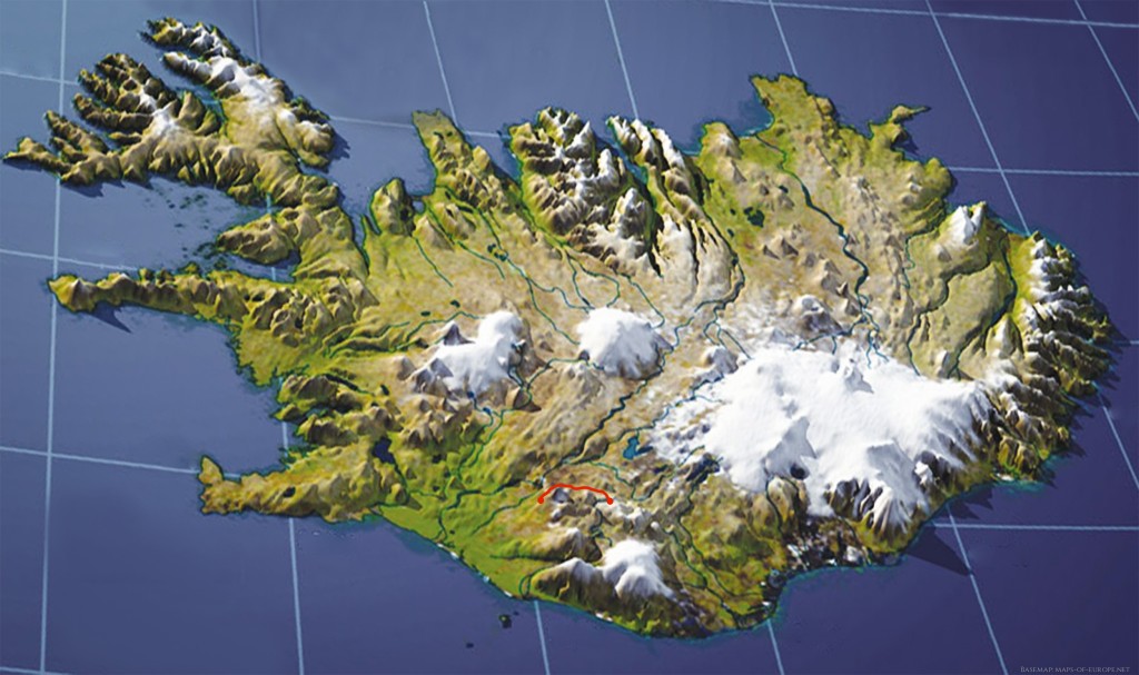
Day 1: Reykjavik - Landmannalaugar Caldera /Hrafntinnusker
Road 140 km- Track 50 km- 5–6-hour hike – Alt. 590 > 1000 m - Alt. 500 m > 1000 m (1940 ft. >3280 ft.)
Meet your guide and travel companions at the meeting point in Reykjavik and then depart by minibus to our base in the village of Hella. (If this transfer is to be made by regular bus from the Reykjavik bus station, either your guide will travel with you or he will meet you in Hella when you get off the bus from Reykjavik. You will be notified well in advance and we will give you all the necessary practical information). Once we arrive at our base-warehouse, we prepare the midday picnic, check your equipment, then load the travel bags, food and equipment into the trailer of our support jeep. 40-minute jeep transfer then we begin the hike to the tiny farms of Hekla at the southern foot of the volcano.
70 km later driving North we arrive at the edge of Mount Hekla where we turn due east on the Domadalur scoria track "The Valley of Judgement" to reach after 20 km the foot of the Hrafntinnusker caldera.
We start to climb the northern flank of the caldera up to the crown that borders it and then start to cross it towards the south.
Progression through the shimmering colors of the rhyolitic massifs on the heights of Landmannalaugar. Incredible palette of pastel colors, from blue to pink, including all possible ochres. Countless fumaroles, pools of sulphureous mud, flows of vitrified obsidian, swamps, clear lakes and immaculate ice caps follow one another as far as the eye can see. We walk along a vast flow of obsidian Hrafntinnusker, “the reefs of raven black”.
Obsidian is a black vitrified lava with sometimes blue or green reflections, which when broken is sharp as a razor blade that spreads here on the soft pastel undulations of acid rocks of the crown of the caldera of the same name. We will carefully see the countless solfataras with pools of bubbling mud, powerful and noisy jets of steam.
Day 2: South Fjallabak – Tindfjöll
6–8-hour hike – approx. 16 km (10 miles) – Alt. 1000 m > 550 m (3280 ft.> 1800 ft.)
As you descend towards Fjallabak South, you can admire the alignment of the mountain ranges, all perfectly parallel and aligned in the same direction, the direction of the Mid-Atlantic Ridge that crosses Iceland from North to South. In good weather, you have a spectacular view of three large ice caps: Mýrdalsjökull, Eyjafjallajökull and Tíndafjallajökull.
The path takes a long, thick palagonite ridge to the southwest that leads to the imposing alpine massif of Tindfjöll. This regular ridge is a balcony over the region: On the right, to the north, a vast territory linked to the Hekla volcanic system with dominant black and red, on the left towards the south, a gray landscape stained with fluorescent green, a jumble of worn and jagged mountains of palagonite resulting from ancient subglacial eruptions
In a fold of this ridge, as if set in a case, hides a beautiful lake of crystal-clear water. Like all of Iceland, the calm of the place results in fact from powerful geological cataclysms, here the lake of Skyggnisvatn is a maar, a phreatic eruption.
Day 3: Krókur (The hook)
6-8-hour hike - approx. 15 km (9 miles) - Altitude 700 m > 550 m (2300 ft. > 1800 ft.
Progression through the mini territories that lead to the very foot of the Tindfjöll massif through green valley’s where streams of crystal-clear water meander, marshes dotted with cotton grass, deep canyons, beautiful green hills. Krókur "the hook" is a sharp turn in the Markarfljót a turquoise river that winds between cones covered in green moss. This territory could well be an advanced observation post of the Kingdom of the Elves just on the edge of the desolation of Mordor.
Day 4: Tindfjöll - Hafrafell - Hella
4-5 hours hike – approx. 12 km (8 miles) – Alt. 550 to 150 m (1800 ft. to 500 ft.)
The Tindfjöll called "The Peaks" is a small chain of majestic mountains with several small, distinct peaks, including the largest Ýmir (1462m) and Ýma (1448m) whose names evoke giants of Scandinavian mythology at the creation of the world.
Of course this is not the Himalayas, nor the Patagonian Andes, but a mixture of the two miniaturized that gives this illusion of virgin immensity which Iceland has the secret. Although Tíndafjallajökull is one of the smallest glaciers in the country, it is located on a giant crater about 7 to 10 miles in diameter formed by the cataclysmic explosion of a large volcano thousands of years ago. Progression across a vast desolate expanse between the Tindfjöll and the volcanic system of Hekla which dominates the horizon to the north of its visible or invisible presence. The loop is complete (Let's say a horseshoe rather than a loop).
In the early afternoon, departure by jeep towards the southwest by the Fjallabak South track, first on the volcanic expanses of the southeast of Hekla then rapid descent through the beautiful moors and meadows to our base of Hella where we arrive in the middle of the afternoon.
- Return to Reykjavik (via Hella) where we arrive in the early evening, either by regular bus or with one of our vehicles.
- Or bus transfer to the ferry pier for an individual 3-day / 2-night extension in the Vestmannaeyjar Islands Archipelago (see online program)
Trek Start and Return
Our treks in the southern highlands begin and end at our base and warehouse in Hella.
The village of Hella is located on Ring Road No. 1, 100 km southeast of Reykjavik, on the vast "pampas" that stretches to the foot of the southern volcanoes and glaciers.
Travel from Reykjavik to Hella
Either we pick you up your Reykjavík accommodation with one of our vehicles (*)
Or by one of our vehicles from a meeting point in central Reykjavik (*)
Or by regular bus to Hella from the Central bus station (8:00 a.m. > 9:22 a.m.)
Arrive in Hella a day earlier
Of course, if you prefer to arrive in Hella the day before the trek starts, this is possible, provided you have booked accommodation in this village. (Departure from Mjódd at 3:15 PM, arrival in Hella at 4:37 PM.
Accommodations in Hella: Hotel Stracta, Hotel Mosfell, Arhus Cottages, Riverside guesthouse...
We can book a room in Hella for you, depending on hotel availability.
Return to Reykjavik
Either by regular bus from Hella (D: 21:26) to the Mjódd bus station in Reykjavik (A: 22:48)
Or by one of our vehicles to the center of the capital (*)
Or by one of our vehicles in front of your accommodation (*)
(*) Depends on the size of the vehicle, as traffic is limited in the city for larger vehicles.
If you are traveling with your own vehicle, you can park it in our parking lot in Hella for the duration of the trek.
Excursion to the Vestmannaeyjar Islands after the trek > Click here
- At the end of the trek, take a bus from Hella (4:49 p.m. > 5:30 p.m.) to Landeyjarhöfn pier, the ferry port for the islands.
- Return to the Mainland by ferry, take a regular bus for a 2-hour drive from Landeyjarhöfn pier to Reykjavik. There are two bus schedules: morning (10:45 a.m. > 12:45 p.m.) or evening (8:45 p.m. > 10:45 p.m.).
Information about this trek
Difficulty level:
- 2-3 Moderate
- Average walking per day: ca. 15-16 km (9-10 miles)
- Total walking distance: ca.48 km (30 miles)
- Altitude between: 700 m and 1200 m
- Positive gradients: ca.1200 m (ca.3900 feet)
- Downhill gradients: ca.1000 m (ca.3280 feet)
Itinerary and security:
The day by day program can be modified or even reversed. However, these changes are rather rare for reasons of safety due to natural phenomena: volcanism, early or late snowfall, bad weather, flooding rivers, exceptionally unfavorable weather ... The guide knows the terrain well and is sole master in interpreting the whims of all-powerful nature on this volcanic earth under these high latitudes, and to make the necessary decisions.
Composition of the group:
In general, the participants of our trips come from several countries: French speaking from Switzerland, France, Belgium and Quebec but also English speaking people from Great Britain, Ireland, United States (Democratic trending), Australians, New Zealanders or other nations who know how to express themselves in English like Scandinavians, Germans, sometimes Japanese or Russians, and even sometimes Icelanders.
Your Icelandic guide is perfectly or sufficiently fluent in English and masters very well at least one or two other European language. Traveling with Fjallabak can represent a unique opportunity to meet, exchange ideas and socialize with companions from other countries than yours that you might otherwise never have approached. A unique opportunity to make friends from all around the world and twist the neck to certain prejudices and misconceptions inked
Languages spoken:
The departure dates are all marked as:
¬ International, (multinational is more accurate) this means that the guide can express himself in English and possibly in French or German or Italian, or Spanish, etc. Participants can be from all around the world if they speak English and/or French
¬ English means that the guide and the group speaks only English. That said, this guide probably speaks also other languages, which may be French (please consult). The group is made up of participants from English-speaking countries or participants from non-English speaking countries with good English skills.
¬ French, it means that the guide is French-speaking as the group that is composed solely of participants from French-speaking countries (Swiss, French, Belgian, Belgian, etc.) or non-French speakers wanting to improve their French. If you want to test your French, do not hesitate
Group size:
Group of 4 to 10 (+/- 1) participants (Note: for groups of 4-5 people, a small group supplement applies) Fjallabak staff or representatives of Fjallabak accompanying professionals (photographers , Journalists, etc.) and other discounted travelers such as children are excluded from the number of participants (minimum and maximum).
Early Birds Discount:
This discount does not apply to children who are entitled to the family discount
- 10% "Early Bird" Discount up to 150 days before departure
- 5% up to 90 days before departure
Family Discount:
Children accompanying their parents or grandparents are entitled to the following discount
- -10% for young people aged 12 to 17
- -20% for children up to 11 years old
Small group surcharge and modified organization:
- ISK 60.000/pp (ca. + € 400) for 5 participants
- ISK 75.000/pp (ca.+ € 500) for 4 participants
In the exceptional case of poor registrations on a departure and you are only 4 or 5 participants registered, in order not to cancel everything you will leave with only one member of our team as guide-driver. You will sleep in the shelters that are planned in the itinerary, but each day there will be a trip by jeep to then make large loops on foot in the most beautiful places
Accommodation:
Sleeping bag (your own) in mountain refuges and huts: Bunks with comfortable mattresses. Running water and kitchen in the shelter, but the toilets and sinks are usually outside, a few yards in a small building apart. Warm hot showers with charge are available in some huts. If you want more privacy during the night while we sleep, we offer you the possibility of sleeping in tents that we provide, please notify us in advance. On the treks where camping nights are planned, the camps are made up of double tents (or single on request) with a comfortable and insulated mattress and a large equipped mess tent.Electricity: take enough batteries for your camera because you will not often be able to recharge batteries in the huts. Also take a normal charger (220v for European standard outlets) as there are some shelter that have electricity.
Food:
We pride ourselves for providing the best cuisine in the highlands! Breakfast is Scandinavian style, with muesli, breads, jams, smoked fish, charcuterie and cheese. The picnics can be a bit repetitive after a week (we are in Iceland), with a variety of sandwiches, smoked meats and fish, excellent local cheeses, green salad, tomatoes and cucumbers. Dinners, varied and often excellent, include fish and lamb dishes, served with pasta, rice or potatoes, vegetables and a green salad.
However, vegans will have to supplement their luggage even though we can accommodate their needs.
For conviviality, but without obligation, you can bring with you a specialty of your country as well as a good bottle of alcohol.
Accommodation during the trek: Sleeping bag accommodation in mountain huts and huts (usually a comfortable and mixed lodging) and according to the itinerary and the conditions, at the peak of the season a few nights might be spent in spacious double tents equipped with comfortable mattresses. Showers are available in some huts, not all.
Food, special diets:
It is essential that vegetarians specify what is banned from their menu, such as those suffering from food allergies (lactose, gluten, etc.). It is important that you advise us of your special food requirements at the time of booking. If the list is long or there is danger with certain allergies, please send us the details by mail to these two addresses <matta@fjallabak.is> so that the team in charge of our warehouse/storage can take this into account in the preparation of food. Your guide will be aware of your plan, but it does not necessarily mean that he is a specialist in that matter, so it's up to you to tell him about it at the beginning of the journey when preparing the first meal! It is also up to you to control at each meal what suits you.
Each day a 4x4 vehicle carries the luggage and the food from hut to hut. We do not see this vehicle during the day, because it takes tracks that we rarely encounter. Someone feeling tired one day can make the trip with the driver (often a friendly guide of our team) which will make him discover another aspect of the highlands. Our carbon impact is lower because the kilometric average of the vehicle does not exceed 30km / day.
Preparation of the trip and notes:
This is an assisted hut to hut trekking. At the peak of the season, we might camp for a night or two. The level of walking is moderate to sustained. You only carry a light bag containing what you need for the day. This trek does not present any serious difficulty for people in good physical shape having at least some experience of long walks in the mountains. An experienced guide leads the trek. This trek passes through totally desert areas. Most of the walking is off-trail, with ever-changing terrain conditions. Therefore, sturdy hiking shoes that fit well your feet are a must. Most days involve river crossing, so it is essential not to forget your sandals. See our kits list for more information. You hike 6-7 hours per day, on average, but it can be longer, depending on the weather, the average level of the group. The maximum altitude does not rise more than 1000m. The change of altitude for most days does not exceed 300 m.
Participation:
An experienced Icelandic guide leads the trek. As we are not in Nepal but in Iceland, it is expected that the members of the group lend a helping hand to their guide in the preparation of meals, washing the dishes, cleaning the floors before leaving the huts, setting up and taking down the tents when camping. Once in the mountains, the group becomes an independent entity. Fellowship, teamwork and forged friendships add much to the richness of each person's experience.
This is an interactive map. Click on the icons and the trail to get more information and photos.