“Those who wander are not necessarily lost” - JRR Tolkien
One great 14-day trek crossing the most spectacular landscapes of the southern highlands from volcano Mt Hekla to Vatnajökull icecap
Our guides, all experienced mountaineers, will lead you safely through this incredible region. Starting at the foot of the imposing Hrafntinnusker caldera over the Landmannalaugar Valley we will walk through the caldera, trough the Desert of Mælifellssandur along the icecap of Mýrdalsjökull and the fault of Eldgjá, to reach the incredible turquoise blue Lake Langisjór near mighty Vatnajökull.
This trek will lead you through a world of volcanic features – huge lava fields, mountains of rhyolite, basalt, obsidian and pumice, through hot springs and fumaroles, blast craters and fissures. You will discover dream-like, moss-filled valleys and drink from the freshest, clearest streams. And always watching over you are the majestic, shimmering icecaps, dormant volcanoes surrounded by vast black sand flats, criss-crossed by a myriad melted water streams.
Presenting no difficulty for good walkers, on most days each member carries only a light daypack as a 4x4 truck carries all personal belongings, heavy equipment and supplies. Every day involves an average of 6-8 hours hiking. Accommodation, during the trek is a combination of some nights in comfortable expedition tents and some nights in well equipped mountain huts, all in beautiful locations. The isolation and severity of the landscape demands each tour member to be in good physical condition and that they actively participate in the trip i.e. the group must work together to set up camp, prepare food etc. This trek is designed for those who wish to fully experience unspoiled nature at its best, and to see what they may never even have dreamed still existed.
This trek is especially designed for those who desire a full immersion in the pristine nature with the discovery of landscapes that are beyond imagination.
This long trek is a combination of Trek Origin of Earth (West) + Trek to Lake Langisjór
To privatise this trek: > Click here
This trek, as described here, can be privatized for your family, for your hiking club, for your university, for your company or for your clients if you are a mountain guid:
- either on one of our scheduled dates still available
- or on any other date if availability allows
| Code | From |
to |
Duration |
Price / Estimated |
Language | Avail. |
Book |
|---|---|---|---|---|---|---|---|
To change the indicative price in your prefered currency, choose it from the available list in the upper right-hand corner of this page.Conversion rates are from the Icelandic National Bank |
|||||||
Day 1: Reykjavik - Mt Hekla farmland
3-4 hours – ca.10 km ( 6 miles) Altitude 135 m to 175 m (443 to 574 feet)
Early morning rendezvous at 7:30 AM with your guide at Reykjavik Central Bus station. Hiking clothes, duffle bag and daypack ready for trekking. The trip begins. Approx. 3 hours (160 km) road transfer to the trailhead. The majestic Hekla volcano rises above a grassy plain and marks the entrance to the high volcanic lands. Probably It is Iceland’s most famous (or infamous!) and active volcano. Hike starts by late morning crossing grassland. The few little farms of the area have had to move many times over the centuries as eruptions have engulfed them. However, much of the countryside is now verdant with some former lava flows covered in green moss and arctic birch. Green moss, « bonsai » arctic birch grove along with the pure water springs, creates the feeling, perhaps, of a real Japanese garden. In August on this day, we can take a little longer as the berry and mushroom picking gets in the way of our passage.
Day 2: West side of Mt. Hekla – The doors of Hell
6-8 hours – ca.22 km (14 miles) Altitude 175 m to 320 m (574 to 1050 feet)
We cross the river Western Rangá, then we hike the last series of hills made from palagonite rock (sub-glacially formed) that protects the last fragments of burned countryside. On the far side, we arrive onto a moon-like surface at the foot of Mount Hekla and cross a stretch of perfectly flat volcanic slag. The black surroundings, so dark they resemble the blue colour of a crow’s feathers. Tiny, we are moving in a completely mineral world of infinite slag plain along the eastern flank of the volcano, which has been vomited most of the cast of the latest eruptions.
Day 3: Valagjá – Mont Loðmundur
6-7 hours – ca.17 km (11 miles) Altitude 320 m to 590 m (1050 to 1940 feet)
We walk away from “the Gateway to Hell” (as Hekla was known in the middle ages) and the landscape begins to soften; the green colours of the mosses slowly covering lava fields and the pumices that rain on the land with each eruption. Crossing the “pass of the lambs” we walk in the direction of the majestic monolithic crown of Mount Loðmundur, surrounded by marshland and rich pasture, reflecting in the beautiful lake Loðmundarvatn reflecting Mount Loðmundur a flat-topped volcanic monolith that erupted through glacial ice during the Ice Age. Landmannahellir has been for ages and it is still used now by the shepherds as a base when catching thousand sheep in fall after having been grassing free the whole summer. We are in a legendary place with thousand stories to tell
Day 4: Walk to Landmannalaugar
Hiking from 6-8 h - approx.1! Km - Altitude 590 m> 700 m
The trail leads us through extraordinary landscapes. First we go around the beautiful lake that shines at the foot of Mt Loðmundur. Then we climb up the northern flank of the Caldera de Hrafntinnusker and enter the pastel colors of acid volcanism. Extraordinary view of the notorious Landmannalaugar Valley famous for its incredible natural beauty in all shades and colors.. We begin the descent towards the refuge and the campsite of the valley, a little surprised to meet suddenly so many people, vehicles and tents after 4 days of wonderful loneliness. After a bath (optional) in the( too) famous warm river, return by vehicle to the tranquility of Landmannahellir away from the crowds
Day 5 and 6: The Black Raven Reefs
Each day hikes 6-7 hours – ca. 17 km (11 miles) – Alt. 590 m up to 1100 m down to 785 m (2575 to 2575 feet)
The metaphor “Black raven reefs” is a perfect example of the natural poetry of the old Icelandic language. (Hrafntinnusker: Hrafn for raven, tinna for black and sker for reefs) A big loop to explore the incredible caldera. More obvious are the amazing rhyolite mountains, formed in incredible bands of pink, brown, green, yellow, blue, purple, black, white, orange and red and glittering with innumerable black, glass-like obsidian lava… Walking among countless bubbling, steaming hot springs, we cross this pearl of the interior, famous for its incredible natural beauty
Day 7: Hike Ljósártungur to Hvanngíl
7-5 hours – ca. 21 km (13 miles) – Alt. 785 to 550 m (2575 to 1800 feet)
With day 2 this day is one of the longest
One can admire here the alignment of mountain ranges, all perfectly parallel and aligned in the same direction: the direction of the mid-Atlantic ridge that crosses Iceland from North to South enjoying a spectacular view of three major icecaps : Mýrdalsjökull,Eyjafjallajökull and Tíndafjallajökull.
Following the course of the Markarfljót canyon, we descend south through hills of rolling grassland, crossing clear streams.
Day 8: Mælifellssandur
5 hours – ca. 15 km (9 miles) – Alt. 550 to 563 m (1800 to 1850 feet)
We cross the sand of Mælifellssandur. In the middle of this strange black flatness stands the solitary cone of Mælifell, covered in fluorescent green-coloured moss. We are able to explore the extraordinary landscapes between the southern flank of the Torfajökull caldera and the mighty dome of the Mýrdalsjökull icecap. Beneath this huge sheet of ice lies Katla, another of Iceland’s angriest volcanoes. She last erupted in 1918 and is long overdue for another eruption.
Day 9: Strútslaug - Lake Hólmsárlón
6-7 hours – ca. 19 km (12 miles) – Alt. 563 to 563 m (1850 to 1850 feet)
Proceed to the shores of the long and narrow Hólmsárlón Lake. We reach the place nicknamed the red baptismal fountain. The waterfalls at the end of the turquoise coloured lake plunging into the red crater, is a sight to behold. Of course, we cannot resist taking a bath in Strútslaug, a nearby, natural hot spring pool.
Day 10: Strútur - Alftavötn – Holaskjol
6-7 hours – ca. 22 km (14 miles) – Alt. 563 to 444 m (1850 to 1460 feet)
We follow the fault of Eldgjá, the longest eruptive fissure on earth, today covered by moss and crossed by a clear stream. As large as the Laki eruption was, it was exceeded by Iceland's A.D. 934-940 Eldgjá eruption, which occurred in the same mountainous region. During the six years that this eruption was active, lava erupted from several vents along a discontinuous 75-km-long (47-mile-long) fissure system and buried more than 781 square km (302 square miles) of southern Iceland. Fortunately, huge eruptions like those at Eldgjá and Laki are very unusual; otherwise, life as we know it would probably not be. Though the hazards posed by lava flows and volcanic gas here on the “Big” Island are understandably important to us, they are still tiny in comparison to what our big blue planet is capable of.
Day 11: Eldgjá – Öxnatindar
5-6 hours – ca. 16 km (10 miles) – Alt. 330 to 450 m (1080 to 1480 feet)
We walk again throughout the Eldgjá break, “throat of fire”, the biggest eruption break on our planet. Despite all these superlatives, tiny little landscapes are comfortable: springs, streams of clear water, small Zen gardens...We reach the heavy Skaftá and its powerful and worrisome waters. On the other side lies the endless lava of Laki, which is the largest lava emission of historical times (1783-1785).
We walk again throughout the Eldgjá break, “throat of fire”, the biggest eruption break on our planet. Despite all these superlatives, tiny little landscapes are comfortable: springs, streams of clear water, small Zen gardens...We reach the heavy Skaftá and its powerful and worrisome waters. On the other side lies the endless lava of Laki, which is the largest lava emission of historical times (1783-1785).
Day 12: Skaftá – Sveinstindur
5-6 hours – ca. 18 km (11 miles) – Alt. 450 to 600 m (1480 to 1970 feet)
We reach Sveinstindur, the first cone of the divided chain of Fögrufjöll, with its conical black and green volcanoes. Easy ascent of Mount Sveinstindur, from where you can admire a fabulous panorama view. To the north and the mighty Vatnajökull the fabulous jade green narrow lake of Langisjór. At the South lie the strange lava fields of Laki, covered with green fluorescent moss, and partly flooded by the overflows of Skaftá.
Day 13: Langisjór and Fagrifjöll
7-8 hours – ca. 20 km (12 miles) – Alt. 600 to 600 m (1970 to 1970 feet)
Along Langisjór and up on easy hills we follow the narrow ridge of the Fagrifjöll. Their name means the beautiful mountains. Knowing the sobriety of the Icelandic language, they must be on to deserve such an appellation. We are moving on the narrow green and black backs of Fagrifjöll, sometimes on the shore of the lake, sometimes the easiest buttes.
Day 14: Grænafjallsgarður - Holaskjol - Landmannalaugar - Reykjavik
2-3 hour hike - approx. 10 km - 120 km track - 120 km road
(Possibility to leave the group at Landmannalaugar if you want to visit this famous region by yourself: ask us for information) We progress due west on a black and green valley bordered by imposing palagonite alignments of Grænnafjallsgarður and Gréttir to reach first by walking, then with the help of our jeep the Fjallabak North track. Either we return by the south coast or via Landmannalaugar where we stop for a short walk of 2 or 3 hours. Late arrival in the capital around 8 p.m.
Currently it is not possible for us to specify in advance which route will be chosen to return to Reykjavik. But we will try to answer you before the trip if you need this information.
- Difficulty level: 3-4 sustained to engaged
- Average daily distance: approx. 14-16 km / 9-10 milles
- Total distance traveled: approx. 210 km / 130 milles
- Total walking time: approx. 70 hours
- Altitude between: 400 m and 1000 m / 1300 ft and 3300 ft
- Positive gradients: ca.3.500 m (ca. 11.500 ft)
- Downhill gradients: ca.3.000 m (ca.9.900 ft)
Itinerary and security: the day by day program can be modified or even reversed. However, these changes are rather rare for reasons of safety due to natural phenomena: volcanisme, early or late snowfall, bad weather, flooding rivers, exceptionally unfavorable weather ... The guide knows the terrain well and is sole master in interpreting the whims of all-powerful nature on this volcanic earth under these high latitudes, and to make the necessary decisions. Composition of the group: In general, the participants of our trips come from several countries: French speaking from France, Switzerland, Belgium and Quebec but also English speaking people from Great Britain, Ireland, United States (Democratic trending), Australians, New Zealanders or other nations who know how to express themselves in English like Scandinavians, Germans, sometimes Japanese or Russians, and even sometimes Icelanders.
Your Icelandic or French guide is fluent in French and English and masters very well at least one other European language. Traveling with Fjallabak can represent a unique opportunity to meet, exchange ideas and socialize with companions from other countries than yours that you might otherwise never have approached. A unique opportunity to make friends from all around the world and twist the neck to certain prejudices and misconceptions inked
Languages spoken: the departure dates are all marked as:
¬ International, (multinational is more accurate) this means that the guide can express himself both in English and in French (possibly in other languages). Participants can be from all around the world if they speak at least one of these two languages: French and / or English
¬ French, it means that the guide is French-speaking as the group that is composed solely of participants from French-speaking countries (Swiss, French, Belgian, Belgian, etc.) or non-French speakers wanting to improve their French. If you want to test your French, do not hesitate
¬ English means that the guide and the group speaks English. That said, this guide probably speaks also other languages, which may be French (please consult). The group is made up of participants from English-speaking countries or participants from non-English speaking countries with good English skills.
Group size: Group of 4 to 12 (+/- 1) participants (Note: for groups of 4-5 people, a small group supplement applies) Fjallabak staff or representatives of Fjallabak accompanying professionals (photographers , Journalists, etc.) and other discounted travelers such as children are excluded from the number of participants (minimum and maximum).
Extra charge per person for small groups:
• ISK 36,000/pp (ca. + € 300) for 5 participants
• ISK 60,000/pp (ca.+ € 500) for 4 participants
Accommodation: sleeping bag (your own) in mountain refuges and huts: Bunks with comfortable mattresses. Running water and kitchen in the shelter, but the toilets and sinks are usually outside, a few yards in a small building apart. Warm hot showers with charge are available in some huts. If you want more privacy during the night while we sleep, we offer you the possibility of sleeping in tents that we provide, please notify us in advance. On the treks where camping nights are planned, the camps are made up of double tents (or single on request) with a comfortable and insulated mattress and a large equipped mess tent.Electricity: take enough batteries for your camera because you will not often be able to recharge batteries in the huts. Also take a normal charger (220v for European standard outlets) as there are some shelter that have electricity. Food: We pride ourselves for providing the best cuisine in the highlands! Breakfast is Scandinavian style, with muesli, breads, jams, smoked fish, charcuterie and cheese. The picnics can be a bit repetitive after a week (we are in Iceland), with a variety of sandwiches, smoked meats and fish, excellent local cheeses, green salad, tomatoes and cucumbers. Dinners, varied and often excellent, include fish and lamb dishes, served with pasta, rice or potatoes, vegetables and a green salad.
However, vegans will have to supplement their luggage even though we can accommodate their needs.
For conviviality, but without obligation, you can bring with you a specialty of your country as well as a good bottle of alcohol.
Accommodation during the trek: Sleeping bag accommodation in mountain huts and huts (usually a comfortable and mixed lodging) and according to the itinerary and the conditions, at the peak of the season a few nights might be spent in spacious double tents equipped with comfortable mattresses. Showers are available in some huts, not all.
Food, special diets: It is essential that vegetarians specify what is banned from their menu, such as those suffering from food allergies (lactose, gluten, etc.). It is important that you advise us of your special food requirements at the time of booking. If the list is long or there is danger with certain allergies, please send us the details by mail to these two addresses <matta@fjallabak.is> and <lager@fjallabak.is> so that the team of our warehouse/storage can take this into account in the preparation of food. Your guide will be aware of your plan, but it does not necessarily mean that he is a specialist in that matter, so it's up to you to tell him about it at the beginning of the journey when preparing the first meal! It is also up to you to control at each meal what suits you.
Each day a 4x4 vehicle carries the luggage and the food from hut to hut. We do not see this vehicle during the day, because it takes tracks that we rarely encounter. Someone feeling tired one day can make the trip with the driver (often a friendly guide of our team) which will make him discover another aspect of the highlands. A 4x4 assistance vehicle carries the luggage, food supplies and equipment between shelters and camps. We do not see this vehicle during the day, because it takes tracks that we rarely encounter. Someone feeling tired one day can make the trip with the driver (often a friendly guide of our team) which will make him discover another aspect of the highlands. Our carbon impact is lower because the kilometric average of the vehicle does not exceed 30km / day.
Preparation of the trip and notes: This is an assisted hut to hut trekking. At the peak of the season, we might camp for a night or two. The level of walking is moderate to sustained. You only carry a light bag containing what you need for the day. This trek does not present any serious difficulty for people in good physical shape having at least some experience of long walks in the mountains. An experienced guide leads the trek. This trek passes through totally desert areas. Most of the walking is off-trail, with ever-changing terrain conditions. Therefore, sturdy hiking shoes that fit well your feet are a must. Most days involve river crossing, so it is essential not to forget your sandals. See our kits list for more information. You hike 6-7 hours per day, on average, but it can be longer, depending on the weather, the average level of the group. The maximum altitude does not rise more than 1000m. The change of altitude for most days does not exceed 300 m.
Participation: An experienced Icelandic guide leads the trek.
As we are not in Nepal but in Iceland, it is expected that the members of the group lend a helping hand to their guide in the preparation of meals, washing the dishes, cleaning the floors before leaving the huts, setting up and taking down the tents when camping. Once in the mountains, the group becomes an independent entity. Fellowship, teamwork and forged friendships add much to the richness of each person's experience.
Clothing
You’ll need to bring comfortable and adequate clothing to protect you from cold and wet weather, such as polypropylene, capilene, or pile. Wool and wool/synthetic blends are also suitable - though wool, if wet, dries slowly compared to synthetic fabrics. We discourage the use of cotton in wet conditions it dries very slowly. When camping, tents are provided. You will be responsible for bringing your mattress and sleeping bag.
When layering, the innermost layer should be long underwear. The middle layer can be a synthetic turtleneck or wool shirt, and pants. The outermost layer must be a breathable waterproof jacket such as a good quality Gore-Tex wind/rain parka and over-pants.
For quantities for each item listed, use your own judgement, based on the expected weather conditions and overall packing/weight restrictions for your luggage.
- Regular underwear. Synthetics are easier to wash and dry
- Synthetic thermal underwear
- Long-sleeved, synthetic or wool shirt
- Short-sleeved synthetic or cotton/synthetic T-shirts
- Medium-weight synthetic fleece sweater or jacket
- Full-length pants, quick-drying synthetic fabric
- Down jacket from mid-August to September (optional)
- Hiking shorts, quick-drying synthetic fabric
- Pile/fleece pants, ideal for around the camp
- Sun & rain hat
- Wool hat
- Gloves (wool or pile)
- Waterproofed shell gloves
- Medium weight synthetic socks
- Gore-Tex rain/wind parka
- Gore-Tex rain/wind pants
- Hiking boots, medium-weight, all leather, with padded ankle, good ankle and arch support, and a lug sole traction. Your hiking boots should be waterproof, well broken in, and suitable for rocky terrain or possibly snow.
- Comfortable shoes to wear when not hiking (optional) Teva-type sandals for river crossing. Absolutely recommended! Gaiters. Highly recommended.
- Comfortable sleeping bag +10°C to –10°C which can be opened all the way
- Cotton sheet to cover the hut’s mattress
- Pillow if you can’t sleep without one (optional)
- Hiking poles
- Swimsuit and towel for hot spring bathing and swimming pool
- 1-to-2 liters capacity unbreakable water bottle or thermos
- Headlamp or small flashlight with spare batteries (essential from August onwards)
- Swiss Army-type pocket knife (Must be kept in duffle bag, not in hand luggage, when flying !)
- Sunglasses
- Eye shades. Highly recommended from April to last July!
- Wax ear plugs
- Spare pair of prescription glasses, prescription sunglasses, or contact lenses (but not only lenses, as wind-blown dust can make them very uncomfortable)
- Toiletry kit—soap, toothbrush, and so on.
- Moisturizing lotion. (The air in Iceland is very dry)
- Sunscreen and lip protection (The sun in Iceland is much more intense than you probably imagine)
- Personal first aid kit
Optional Travel Accessories
- Binoculars
- Repair kit with needle, thread, and safety pins
- Reading and writing material
- Your favorite snack food such as raisins or chocolate
- Protein supplements for vegetarian
- Your own food reserves if you are vegan
- 1 or 2 good bottles of wine or a bottle of something stronger
- Netting hood in June and July *
There are no mosquitoes in Iceland (not yet), but in early summer midges swarms invade the banks of rivers and lakes in the lowlands like Lake Myvatn "Lake of gnats." With global warming now midges start to colonize certain areas of higher land with swamps vegetation. The outbreak period is short, but extremely difficult for the hiker. Gloves a long sleeve shirt and especially a safety netting hood that slips over your hat or cap can save you if you find yourself a day without wind in the midst of clouds of these very annoying critters. You will certainly not use it but in case... and that's not a huge investment.
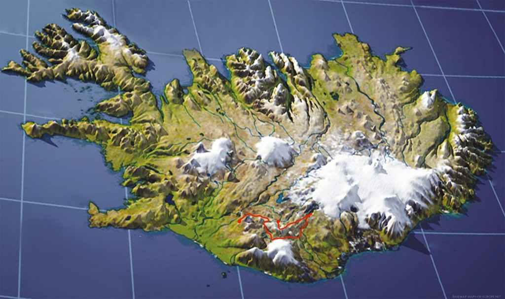
This is an interactive map. Click on the icons and the trail to get more information and photos.
(If you zoom in very close, the landscape changes to a winter wonderland. That is because the satellite images were taken in winter. There will be no snow on your trek.)